Friday 13 December 2013

Australia Dec 2013

Travelogue 16 Stage 3
South Australia
  
Pelicans, Streaky Bay
Once in South Australia, via the Nullarbor Plain, the scenery changes from that of scrubby desert to vast tracts of grains - rolling plains of golden wheat, barley or canola stretching to the horizon, each perhaps 300 to 700 hectares.  At times, one would drive into a small town totally reliant on the grain crops, with huge silos first seen from a distance. This year's bumper grain crop is expected to produce over 650 million tonnes, a record for many years, and the small towns are busy with the comings and goings of loaded road trains.

Streaky Bay, Eyre Peninsula
After leaving Ceduna on November 9th, it was on to Streaky Bay in the Eyre Peninsula for a bit of coastal relaxation. Though picturesque,after two nights the freezing southerly wind meant we decided to head inland for a bit more warmth.  We cut across the top of the Peninsula, stopping two nights at Kimba, a small town overshadowed by the usual huge silos.This pleasant town is noted as being the Halfway Town, being 'halfway' between Sydney and Perth by road, so a mandatory photo at the decaying Halfway Sign is required.

Kimba's halfway sign- I'm pointing at Kimba on the map
Iron Knob mine pit -90 metres to the bottom
From Kimba, it was on to Iron Knob, where we'd been told of a free campsite in the heart of the town.  Iron Knob was a step back into Australia's history, almost straight out of a western movie. The settlement appears abandoned, derelict houses with closed doors, weedy streets backdropped by a giant hill of red ore - last vestiges of a once thriving open cast iron mine. We strolled up the main street, where even the dogs were too tired to bark, past the 1950s swimming pool now filled in with gravel, past the defunct picture theatre, to the visitor centre where at last we found life. The staff there were friendly and suggested we go on the mine tour, the cost being whatever we wished to pay.   Being the only ones there we felt they'd surely need more people, but nothing was too much trouble. A phone call and a few minutes later a dusty Toyota Hiace pulled up, emblazoned in the sign -" Iron Knob Mine Tours"  The dust settled, we clambered aboard and were off. Chasing emus up the main street, we then started up the hill where our driver (who turned out to be the father of the visitor centre staff) asked us to open locked gates to allow his coach to get to the top.  Once  there, it was a spectacular view into the bowels of this hill which had been drilled and blasted to extract the ore. This mine is now defunct, but with modern machinery there are hopes to re-open the mine. The townsfolk live with this hope. Their wait could be a long time.
Whyalla lookout over Spencer Gulf

Whyalla is on the east coast of the Eyre Peninsula, a large and thriving town some 70 kms from Iron Knob. Here again is city life - malls, traffic lights, etc. We stayed here five nights, allowing caravanning friends from New Zealand to catch up with us.  The coastal winds still blew ferociously and travelling north, we were almost blown on to Port Augusta at the top of the Spencer Gulf, before battling those same winds on the run south toward Adelaide. 
300 hectare wheat field, Maitland

We pulled off the main highway and after farewelling our New Zealand friends, who were travelling on, we travelled down the Yorke Peninsula to Maitland, where we'd been invited to stay on a 56 000 hectare grain farm. Most of this peninsula is covered in vast grain fields. Our camp was beside one field of over 300 hectares.  The bottom of the peninsula has scenic bays and historic towns and we spent three pleasant nights in the area with our  hosts.

Monday November 25th we arrived in Adelaide, South Australia's capitol city of some 1.2 million people. It was a hot 35 degrees. The next day was 37 degrees.
Adelaide is known as the "
Rundle Mall, centre of Adelaide
City of Churches" and is a pleasant conservative place, with many parks, museums and grand buildings. Adelaide's heart is the Rundle Mall, and the inner city free buses and trams make this a worthwhile visit. The city is bounded in the west by many fine beaches and in the east by the Adelaide Hills. We spent two nights in Adelaide before accepting an invitation to stay with a family in Hahndorf, in the Adelaide Hills.

Hahndorf restaurant
Hahndorf shopping centre

Hahndorf is a perfect picture postcard village in the Adelaide Hills, first settled in 1839 by German migrants. Many of their old stone buildings are still being used today as cafes and craft centres, the narrow main street lined with leafy oak trees which add to the ambiance. You could be in the heart of an old European village.  Near Hahndorf are other pleasant attractions -  bush drives to the lookout at Mt Lofty; elsewhere chocolate and cheese factories, and the world's largest rocking horse at Gumeracha - except it doesn't rock. Our hosts took us on many delightful drives and walks.

Gumeracha Rocking Horse


We had a phone call from our daughters in New Zealand wanting us to arrange a lunch at an Adelaide restaurant, to celebrate our getting across the Nullarbor. Though they wouldn't be there, they implored us to confirm the restaurant so they could arrange payment for the two of us.  We booked a restaurant overlooking the Adelaide coastline and on Saturday December 7th sat down to lunch. A few minutes later, both daughters surprised us, having flown in from Auckland just two hours previously. They'd hidden away until the manager assured them we were there. We were amazed they had gone to so much trouble knowing full well we had no set plans and we could have moved on before they arrived. As it was, we'd arrived in Adelaide two weeks ahead of their 'plans.'

The next four days were a blur of fun as we showed them as much of Adelaide as possible, before they flew home on Wednesday December 11th.  We then packed up and moved on to a cousin's property in Murray Bridge, some 70kms east of Adelaide where the caravan and car will be stored until we return next year.

We'd like now to say a very big Thank You to those people who have helped or hosted us during our travels. You know who you are - our sincere thanks to each of you, though we don't mention names in this blog. We also thank our readers and those who have emailed comments to us. We appreciate your feedback.

We hope you stay with us next year when once again we invite you to join us. Meantime, do have a very memorable and joyous Christmas, and a fabulous New Year.

Merry Christmas 
Seasons Greetings from Aussie


Monday 11 November 2013

Crossing the Nullarbor

Crossing the Nullarbor Plains

Western Australia is separated from the rest of Australia by only two major sealed road routes – the extremely long route up the west coast and across to the centre, and the southern route across the huge area known collectively as Nullarbor Plain, skirting the Great Australian Bight. The Eyre Highway route is a journey along one of Australia’s greatest wildernesses, a 1200km drive across the Nullarbor Plain. Extremely dry, hot, flat, mostly deserted, it's a hard life for those who live there yet every motorist travelling that road is grateful for the infrequent roadhouses where one can fuel up, refresh, stay over and even play golf.


Welcome to the Eyre Highway


Cocklebiddy Roadhouse


Eucla Roadhouse with road train
Balledonia, Calguna, Cocklebiddy, Mundrabilla, Eucla, become more than names on a map, instead places of refuge along the way. Water is precious and most roadhouses sell bottled water only. Crows sip damp mud to gain a little moisture. Frequent roadside areas encourage free overnight camping, and late each afternoon small villages of campers and caravans would appear, gone by next morning. Shade was important, as was protection from the biting march flies. Road trains pass every few minutes,day and night, the lifeblood of Western Australia on the backs of huge trucks and trailers.

Our western start to the Nullarbor Plain was on Saturday Nov 2nd from Norseman, 200 kms north of Esperance. Six days later we arrived in Ceduna, the eastern end of this iconic experience. First night was at a rest area, followed by a night at Fraser Range Station. At 440 000 acres, and 160kms long, it's a normal size station along this route. Dry, dusty and hot, it was the spot to first try our hand at the famed Nullarbor Golf Links, where one plays a hole, drives about 150 kms then plays another hole. Par for the 18 hole course is 72. We used that up on the first hole, so decided to cheat after that.
Golf at Nullarbor Roadhouse-plane taxiway behind Raewyn

Signs across the Nullarbor
We played only two more holes (each about 400 kms apart) and rather than set off from the tee, found it easier starting from the edge of the artificial green. That way, we could miss the rocks, thorns, snakes,crows, ants and most other greebies. That our two golf clubs came from op-shops shows our prowess at this game. (Our second hole, two days later was at Nullarbor Roadhouse where we had to wait while a small plane taxied across the stony ground between us and the hole. We cheated there too.)

The endless highway
Longest straight road in Australia
Much of the route is inland from the coast, the undulating flats with long straights (the longest at 146kms without a bend) disappearing into a vanishing point on the distant horizon. Reach that vanishing point, and another appears just as far away. And it seems this goes on for ever. Not only motorists use the road, but cyclists and runners. We saw two runners at different times, each fund-raising for different charities, both noble but crazy!

Side roads lead off to various points to view the coast, and get a cool breeze from the 38-42 degree heat. At Bunda Cliffs, we were forced away from the viewing point by armies of flies determined to suck every last bit of moisture from us. But we got the photos. At Madura Pass,before the road drops 90m to the Roe Plain, the view over the flat landscape below is so expansive one can see the curve of the earth along the distant horizon.

At Eucla, the road rises slightly again and shortly after we cross the border into South Australia, and put our clocks ahead 2½ hours (SA is on daylight saving – WA is not.) Thereon, pegs every 5 kilometres denote the distance from that border crossing. 25kms, 50kms,100kms gives grateful knowledge we are at least making some progress along the way. We stop overnight at the 81km peg rest area, again with the ubiquitous army of flies. As night falls, the flies depart, the temperature drops from 42 to 30 degrees and a soft breeze murmurs contentment. Only the infrequent drone of road trains disturbs the night air.

Head of the  Great Australian Bight
Next day a side road takes us to Head of the Bight, northernmost point of the Great Australian Bight. From June to October this is a breeding area for right whales, often seen close to the shore. Unfortunately the whales had gone when we visited, possibly driven off by the flies. But the view made up for that. At this point, the land drops sharply into the sea. Rhythmical ocean swells lash constantly at unrelenting cliffs. Deep indigo seas disappear into a blackening horizon. Rain is on the way. Somewhere out there, the whales and their young are migrating back to Antarctica. Behind us lies the vast bulk of Australia.
Already driven 900kms- Not far to go now

That night,in Cohen rest area, thunder disturbs the sky. Three drops of rain fall. Then the storm is over. At least the temperature drops, and the flies go away.

Welcome to Ceduna, eastern end of Nullarbor
Next day, our sixth, a shorter trip passing vast grain fields brings us to our last golf hole at Penong. We cheat again. Later that day, we arrive at the quarantine border just shy of Ceduna. We've already eaten or given away most of our fruit and vegetables, but give up a small bag of raw potatoes as they may have fruit fly in them. Then we're in Ceduna, a coastal town with supermarkets and shops and cheaper fuel and water and paved footpaths. We book into the caravan park. That night it rains heavily. We're grateful.


Looking back  along the Eyre Highway, Australia's iconic journey


Friday 1 November 2013

Australia Aug-Nov 2013
Travelogue 14 Stage 3
Perth-Esperance

We stored our car and caravan and left Perth for New Zealand in December, 2011. Due to circumstances, we were not able to return to Perth until August 3rd 2013, some twenty months later. But that's another story.

Perth was as we had left it, though with atrocious weather further south, we stayed put for over a month, earning a little money painting, had repairs done to our car, met and made friends with many hospitable folk and enjoyed new sights and adventures in and around Perth.

October 4th, we finally left Perth for the southern coast. It was a little sad as we'd made many friends who could not really believe we would leave. But our time had come. We said our goodbyes and were soon on the road.

Cape Leeuwin - note Captain Cow.


Busselton, northern gateway to Leeuwin-Naturaliste National Park, was the first stop. Nearby is the Cape Naturaliste lighthouse. Between that and the Cape Leeuwin lighthouse at the 'bottom left corner' of Western Australia are some of the most scenic parts of the state. With its forests,bays,wineries,green fields and caves to explore, this area felt very much like New Zealand. Sampling locally manufactured chocolate and honey meant our three nights camped on a sheep farm went almost too fast. Cape Leeuwin is where the Indian and Southern Oceans join, normally a rugged exposed wind-swept point. Our day there was fine with a warm breeze, the ocean's swells almost a gentle ripple, a marked change to the previous month's weather.

Inland through heavily forested areas, staying overnight at Pemberton then Walpole, our next major stop was Denmark, a pretty town on the south coast, detouring on the way to visit the Valley of the Giants Treetop Walk where one walks a steel-grilled walkway 45 metres above the forest floor, viewing the tall karri trees and rare giant tingle trees, which grow only around this area. Adjacent is the Ancient Kingdom, full of beautiful paths and buttressed tingle trees, some with burnt hollow centres cause by lightning. The trees
Hollow giant tingle tree, Walpole
themselves were not distressed, for this is part of their natural makeup.

Our stay in Denmark's caravan park was enriched with visits by about thirty kangaroos each evening, and waking each morning to the laughter of kookaburras. Ten kilometres distant was Greens Pool, where a naturally occurring wall of huge rounded boulders about 100 metres off-shore protects the bay from ocean swells, making this sandy bay safe, shallow and warm with clear waters – the ideal spot for Bryan's first swim of the season.

On to historic and busy Albany, southernmost city of Western Australia where we stocked up for the days ahead. Don't go shopping there on a Saturday afternoon, or Sunday. Everything shuts, including the supermarkets.

Stonehernge,  Esperance, WA
Then through Ravensthorpe to Esperance, home to many spectacular beaches, looking across clear waters to a myriad of uninhabited offshore islands. Nearby is Stonehenge, where a farmer has built a full-size replica of Stonehenge in England. The difference is this one is not broken. We could walk between and touch the stones, some weighing more than twenty tonnes. Photos showed how they had put the capping stones on top, but it would be cheating if I told you. Few visitors were there when we visited, the warm sun and trimmed green grass making it an ideal spot for the afternoon.

We had been recommended to stay at Cape Le Grand National Park, fifty kilometres from Esperance. Saturday 26th October, we drove to stay at Lucky Bay, one of two camping areas within this huge park. Being a national park, there is no power, but there were solar-powered hot showers, flush toilets and gas barbecues, and lots of happy hours with other like-minded campers. Each night became a circle of twenty or more fellow campers, each retelling the best walks that day, or best spot for phone reception.

Whenever opals are created, their colours must come from the opalescent waters of Lucky
Lucky Bay - this photo has not been retouched
Bay. Here, the sea is topped with pearl-like surf. Between each lazy wave one can see perhaps eight to ten metres through translucent green water to the white sandy bottom. This area is considered to have the whitest sand in Australia, bettering that of Whitehaven Beach in the Whitsunday Islands, Queensland. About 250 metres offshore, the water changes markedly to the deepest ultramarine blue, and beyond that, bare islets of burnt orange granite stand naked against the sky. At night, the stars shine with a brilliance unseen in any city.

Inland, the park also has many bare and high granite outcrops, one known as Frenchman Peak. At 262 metres, it's a steep, if not scary, 40 degree 45 minute climb to the top, our reward being an uninterrupted view across this massive park. From the peak, this outcrop
Frenchman Peak - note the open cavern near the top
drops very steeply on all sides. At the peak itself, one massive rock of several thousand tonnes forms a natural bridge over a very large open-ended cavern. Inside, swallows make their home with their noisy comings and goings. From ground level, you can look right through this outcrop.

Cape Le Grand
With the wet spring, we thought we'd missed Western Australia's famed wild flower displays. We had been told we were too late, or it had been too wet. But Cape Le Grand lived up to its reputation, and while there thousands of wild flowers opened their blooms.

Our six days there only came to an end when we learned rain was on the way. We're now back in Esperance stocking up for our next stage, Esperance to Adelaide. We hope you can join us.


Wildflowers, Cape Le Grand National Park


Lucky Bay, Cape Le Grand National Park


Australia Aug-Nov 2013

Friday 2 December 2011

Australia Nov/Dec 2011 Carnarvon-Perth

Australia Nov-Dec 2011
Travelogue 13 Stage 2
Carnarvon, WA - Perth
from Bryan and Raewyn
austadventures.blogspot.com


Mile long jetty at Carnarvon
Carnarvon
Our last tales were from Carnarvon, midway along the Western Australia coast, and some 900 kms north of Perth. We arrived there October 5th and a week later were offered jobs cleaning and maintaining the grounds in our caravan park. It was pleasant work, with fine days and warm nights and not long before we found we had been in Carnarvon a month. It was time to move on. We needed to move south out of the summer cyclone/flood zone, (which stretches from Carnarvon to Darwin) yet not reach cold and wet Perth too early. On November 7th we left Carnarvon and followed the coast southwards, flanked by outstanding views of a translucent blue Indian Ocean edged in whitest sand, offshore breakers topping the 260km long Ningaloo Reef, and a crisp blue sky overhead.

3500 mllion years old stromatolites , Hamelin Pool, WA
A detour on the way took us to Hamelin Pool, home to rare rock-like stromatolites. Around 3500 million years old, these fossils are believed to be the oldest living things on earth, growing in warm shallow salty water. Stromatolites give off oxygen bubbles as each tide slowly covers them. Further along this one-way road is Monkey Mia, famed for hand-feeding wild dolphins, but a 300km detour to get back to the main highway meant we gave this a miss. Dolphins are seen often at most beaches along this coast. We stopped overnight at Murchison River Rest Area, surrounded by other campers – and many chummy Australian bush flies. Next day was on to Geraldton.


Geraldton
Pinnacles Desert, WA
Geraldton is an historic coastal town, some six hours drive north of Perth. We stopped a week at Fig Tree, a serviced rest area some16 kms east of Geraldton, surrounded by huge fields of golden swaying wheat. Each evening was 'happy hour' with most other campers involved. Geraldton's weekend markets, historic buildings and fine beaches make it an attractive place, if a little strange as most shops close at weekends. It's a little like going into a time warp.

Cervantes
Strange rocks at Pinnacles Desert, near Cervantes
Sunday 13th November we left Geraldton, and two days later settled into the cray-fishing town, Cervantes, close to the Pinnacles Desert region of Nambung National Park. In all Australia, only in this park are found strange limestone pillars up to 5 metres high, in their thousands. A drive and walk through the park allowed us to get up close and personal with some of the pillars. They are extremely hard and depending on where in the park, are in different coloured groups. Various theories explain how they formed, but not knowing adds to their attraction. Oddly, this site was virtually unknown until the 1970s when it was 're-discovered' by locals.


Perth City from Kings Park
PERTH
A zig-zag trip with a night in Yanchep National Park, surrounded by hundreds of kangaroos, and a detour to the Gravity Discovery Centre, found us in Perth on Thursday, November 18th . With 1.6 million people, Perth is the largest city in Western Australia and considered the world's most isolated city. With its many parks, fine surf beaches, easy transport and agreeable climate, Perth is a very liveable city and home to thousands of NZ expatriates The view over the city from the 400 hectare (1000 acre) Kings Park is perhaps the most renowned view of the city - the Swan River fronting the city skyscrapers, and softened by a ribbon of greenery between river and city. There's a lot more sights in Perth than we have seen in the last two weeks. We've visited the Perth Mint, Fremantle markets and inner-city (where bus transport is free), stayed a week with long-time ex-NZ friends, had dinners with other friends we've made along our journey, and organising storage of our car and caravan. Time is now short, and our exploration of Perth will have to wait until we return next year.

This is the end of Stage Two of our Australian journey. We fly back to New Zealand mid-December, and plan to be back in Perth sometime mid-2012 to continue our journey. Please join us. Should you wish to unsubscribe from the blog email list, please let us know. Comments are also welcome.

Have a Cherry Christmas, an equally wonderful New Year and prosperous 2012.

So this is where we are


Tuesday 11 October 2011

Australia October 2011 Katherine NT - Carnarvon WA

Australia October 2011
Travelogue 12
Stage 2 Katherine, NT- Carnarvon,WA
from Bryan and Raewyn
Web: austadventures.blogspot.com


Katherine
Our last tales were from Katherine, some 300 kms south of Darwin. We spent seven weeks in the Northern Territory, exploring Kakadu and Litchfield National Parks, Katherine Gorge, Alice Springs and many other towns, each an oasis in the vast dry landscape. By mid-September, “the Build-Up” was due, with the barometer slowly climbing as each day's humidity and temperature increased. This annual event culminates in “The Wet” in summer, when much of Northern Australia suffers a barrage of high temperatures and monsoons. Darwin's houses have no gutters, as they cannot cope with these downpours. “The Dry,” in winter, is the most comfortable time to be this far north. September 16th, with the onset of spring and “The Build-Up,” we headed west, wanting to get below the Tropic of Capricorn.

Kununurra
Two days later, we reached Kununarra, a town some 400 kms west of Katherine and 40kms inside the Western Australia border. At the border, every vehicle is inspected for fruit and vegetables, and any found is confiscated. We had been told of the border restrictions, so had eaten up before reaching there. We settled into the Kimberleyland Caravan Park in Kununurra, bordering Lake Argyle. At over 1000 square kilometres, this is the largest freshwater lake in Australia, and home to a third of Australia's bird species. With good fishing, it's also a popular spot for many keen anglers. Kayaking on the lake was a relaxing pastime, and after dark the red eyes of freshwater crocodiles, up to 1.2 metres long, glowed in our torch lights as they hunted fish. These crocodiles are for the most part harmless, and often rested at night on the lake edge, near caravans and tents.

We opted to fish one afternoon at Ivanhoe Crossing, ten minutes north of Kununurra. Here, the road causeway crosses the Ord River, but was closed as a metre of flood water ran across it. Signs warned of estuarine crocodiles (the dangerous ones) so we stayed on the safe riverbank. A few locals did venture onto the causeway to fish, but with its slippery moss, fast flowing water and crocodiles, it could have been disastrous. We found a spot a little downstream, and Raewyn pulled out several abandoned nylon fishing lines which had one end tied to scrubby trees, the other end flapping about mid-air or in the water. One line was particularly tight and on pulling it up, we found it had hooked a very large barramundi, a prime eating fish found throughout Australia. At seventy centimetres, it was near the maximum legal catch size. Though tired from being hooked for possibly several days, it still put up a remarkable fight. We'd thought of leaving it, but obviously the line had been abandoned, and this fish would have only become crocodile tucker, so that night we ate well.

Broome
After four days in Kununurra, it was time to head farther west across this great state to the coast. It took three days to reach Broome, the northernmost coastal town in Western Australia. We overnighted at rest areas with quaint names like Mary Pool, and Nillibubicca (how I remember that name, I don't know) and passed through the isolated frontier-like towns of Halls Creek, Timber Creek and Fitzroy Crossing.

Sunrise, Roebuck Bay, Broome
There was also another route to Broome, a little shorter than our 900 kilometre route. This is the renowned Gibb River Road, a 680 kms 4WD unsealed and corrugated road through the picturesque Kimberley Plateau. Allow up to seven days, the brochures read. Carry plenty of supplies, as water and fuel was limited. We met several who'd driven the road, including one who'd taken his caravan along this road. Never again, he vowed as he assessed the damage to his caravan. You can understand why we stuck to the main highway.

Camels await riders,Cable Beach, Broome
Our caravan site overlooking Roebuck Bay, Broome
At Broome, it was nice to see the blue sea again, the sparkling Indian Ocean. Broome, famous for it's pearling industry, is also renowned for glorious sunrises and sunsets. Our caravan site overlooking Roebuck Bay was perfectly placed. Each morning, the sun rose in deep scarlet hues reflected in the harbour, before melting into a blue sky. Cable Bay, on the ocean side of Broome, is home to popular camel trekking along the beach. Most camels, roped together in chains of twelve and each carrying up to two people complained bitterly as they stood up. Going by the size of some of those aboard, I couldn't blame the camel. One more straw, and it could have been fun. Sunsets at Cable Bay were to die for, cameras clicking furiously along the beach front each night.

Broome's small Chinatown area in the town centre is made up of upmarket pearl stores almost end to end, punctuated by the odd cafe or pub. You can buy pearls here in almost any colour or price. Perhaps the oddest attraction in Broome is the airport. The runway is just at the end of the main street, and when walking this street, you instinctively duck as planes fly over, their wheels seemingly only a few metres above your head.


Emu and chicks on path, Cape Range NP
 Cape Range National Park / Ningaloo Marine Park
After four nights in Broome, we travelled south while the fine weather was still with us. In the next three days, we drove over 1000 kms to reach Exmouth, gateway to the Cape Range National Park and adjoining Ningaloo Reef Marine Park. This coral reef, some 260 kms long is for the most part perhaps one kilometre offshore and home to many varieties of fish, turtles, rays, dugongs, sharks, whales and dolphins. Cape Range National Park adjoins the Ningaloo reef for some 60 kms. With only 112 non-powered sites available within that park, camp sites are almost always occupied. Exmouth Visitor Centre staff suggested we try turning up at the park entrance gates very early the next morning and chance somebody was leaving. We got there at 7.30am. Already three hopeful groups were in front of us, and by 8am, when the park office opened, another ten or so were behind us. Fortunately six sites became available that day,. I think we got the best site at Ned's Camp, only 8 kms into the park. Some campers had to go 50 kms into the park to reach their site.
Sunset, Cape Range National Park

We spent four relaxing nights in the park, overlooking a white sandy beach with the ocean swells breaking over the Ningaloo Reef about a kilometre offshore. Within the park, one could go snorkelling, canyon walking, or swimming in the warm waters. Behind us, low dry scrub covered the ground up to the Cape Range summits and park border. Red kangaroos (the big ones) and emus with chicks were common park visitors. We telephoned our daughters from a phone booth situated near the park information centre. It was rather odd, a phone booth in the middle of a scrub-covered plain, kangaroos hopping around beside us.

October the 6th we left Cape Range National Park to continue our journey south. We were told to not miss seeing Coral Bay, some 150 kms farther. A short detour took us off the main highway to this most beautiful bay, where the coral reef was barely ten metres offshore from a sheltered sandy bay. Both Raewyn and I went snorkelling, and seconds from the sand, you were over the coral reef and a multitude of fish. If we'd had more time, we could venture a little further out to see larger fish and corals. Captivated families played around the beach, and those inclined could go on a glass bottomed boat to see the main reef further out.

Beside this bay, the two caravan parks were a boisterous jam of wall to wall vans, camping trailers and tents vying with each other for space to put their cars,boats, water toys, bicycles and clotheslines. It was school holiday time, and the parks were packed with families and groups making the best of the glorious weather. Fresh water was available to campers at $10 per ten litres. We could easily understand the popularity of Coral Bay, but an afternoon there was enough for us. We spent that night farther south at another roadside reserve, Lyndon River, where another fifteen travellers pulled in for the night.

Carnarvon
Next day, October 5th, we moved on to Carnarvon. Carnarvon is a small and quiet town 900 kms north of Perth. It's West Australia's fruit and vegetable growing area, not really a tourist spot, though there are several caravan parks. With this competition, overnight rates are reasonable so we spent a week there to relax. We don't want to reach Perth too early, as it's still cold there.
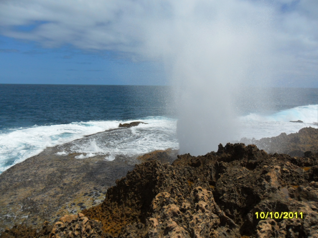
Quobba Blowholes
Though Carnarvon itself is a country town servicing the local market gardens, some 70 kms north are the Quobba Blowholes, a spectacular event on the half tides, where great ocean swells smash into rock shelves, and blast through a series of blowholes reaching about 15 metres into the air. Barely a kilometre south, a safe sandy Point Quobba Beach overlooks a calm sea water lagoon, protected from the Indian Ocean swells by the huge coral reef. At the edge of this huge lagoon, perhaps in only 30 cm of water, a crumbled biscuit or bread dropped into the water immediately brought hundreds of fish into a feeding frenzy around your feet. We went snorkelling in this lagoon, the coral more colourful and fish more plentiful than that of Coral Bay – and with a lot less people Once used to our presence, fish surrounded and accompanied us as we drifted over the corals in the warm clear water.

It seems little noted, even by the local tourist centre, that Quobba is the westernmost point of any sealed road in Australia. But it was another tick in our list of Australian achievements.


Wednesday 14 September 2011

Australia September 2011
Travelogue 11
Stage 2 Alice Springs – Darwin/Katherine
from Bryan and Raewyn
Web: austadventures.blogspot.com


Alice Springs
Our last tales were from Alice Springs, where we spent almost three weeks enjoying the wonders of the red centre. Tuesday 23rd August, we left Alice Springs and retraced our steps north along the Stuart Highway. We'd planned another overnight stop at Devils Marbles as we had done before, but on arrival, flames licked the roadside, and clouds of wind-whipped smoke and ash from a huge grass-fire drifted across the rock columns and roads. Though the campsite itself was clear, any wind change could have meant a panic exit, so we decided to carry on, stopping overnight at Bonny's Well, a little farther up the road. Next day we again passed Three Ways, and with Alice Springs now 500 kms behind us, we entered new territory.
Daly  Waters pub

Daly Waters
We'd been advised to stay a night at Banka Banka Cattle Station, 50kms north of Three Ways. We were greeted by the greenest grass we'd seen for some time, and fresh cool spring water. Happy hour was around a huge camp fire near the original homestead, as a distant dingo howled and talk was of a mob of loose cattle near the road.
Daly  Waters pub
We'd also been told to not miss Daly Waters, some 340kms farther north and four kilometres off the Stuart Highway. In this outback village, the tiny pub is a clutter of bras, knickers, hats, horse gear, money, badges, ID cards and various other paraphernalia attached to every available space. Rusting ironmongery sits in corners and outside, a sign reads “Angle Parking Only Mate – Any Angle You Like”. Adjacent is an open air restaurant which serves 'barra or steak' nightly from about 6pm. We ordered for 6.30pm, dining with friends we'd made along the way. Barra means barramundi, the famous fish of the north. Alongside this pub/restaurant, the caravan park filled quickly with travellers here for this legendary meal, and the comedy and songs show which followed. In true country style, too quickly it all passed, and many happy campers farted their way back to their caravans.


Warm stream at Bitter Springs, Mataranka

Katherine
Next destination was Katherine, via Bitter Springs, Mataranka. Here, clear spring water flows gently alongside palms, ferns and tropical trees. Birds flit amongst the trees, and small fish accompany you in the warm stream. A short track leads to steps to ease into the 33 degree water, and many people take floats to drift some 100 metres downstream to where even more steps make it just too easy to get out. An overnight stop at King River roadside rest area then it was on to Katherine.

With a population around 6000, Katherine is nevertheless an important town in the Northern Territory. Major routes go west to Western Australia, south to Alice Springs or Brisbane, or north to Darwin, some 320kms farther. We booked three nights at a local caravan park, drove in, and almost bumped into a French girl we'd met at Ross River. We'd given her a lift to Alice Springs and said our goodbyes there. She was hurrying to get to Darwin for work. She had got a lift, but at Katherine the van had broken down and she was desperately trying to text us to see if she join us again. Her text came through just as we saw each other, so it was hugs all round. She joined us for our journey to Darwin.
Katherine Gorge

The broken down van belonged to two long-faced German girls. They had been told the alternator needed replacing but the only fault I found was a loose battery which every so often shorted out against the van body – easily fixed. As a test drive, the next day we all went to Katherine Gorge National Park, some 25kms east of Katherine. Endowed with rugged gorges, thousands of bats, kangaroos, snakes and crocodiles, the area is spectacular and well worth the drive. The five of us opted to walk some 30 minutes to the lookout, which gave a wonderful vista over the first gorge. In the 35 degree heat, we decided to not walk to the next gorge, some 7 kms further in. There's thirteen gorges in this national park. (The fixed van performed well, and our delighted German girls drove on to Darwin the next day.)
Mindil Beach sunset, Darwin


Darwin
From Katherine, it was but a short 200km hop to our next overnight stop at Adelaide River. Though just a whistle-stop town, Adelaide River is home to the Northern Territory's Commonwealth War Graves, final resting place of the hundreds of military personnel who died defending this part of Australia during WW2.
Darwin Beach and harbour
Then it was on to Darwin arriving there on a 34 degree last day of August. First visit was to the Mindil Beach Sunset Markets, on Thursday nights. This is a colourful mass of music, entertainment and food stalls bordering the beach. The outstanding moment was perhaps the sunset over Darwin Harbour. Most market-goers, perhaps 800, walked the few metres to the beach to sit on the dunes as the setting sun turned the sky deep red, the sea afire with shimmering ripples of golden light, ending only where the last wavelets touched the shore. Add to this the two didgeridoo players who decided playing to a packed beach crowd was better than playing to an empty market and you get some idea. The sun dipped below the horizon, the sky went through purple to indigo, people roused themselves from the dunes and went back to the markets, now ablaze in colourful night lights.

Crocodylus Park
Another day was to Crocodylus Park, which contains over 1500 salt water crocodiles, some bred there, others rogue crocodiles brought in from outlying areas, including one found in Darwin Harbour. Feeding them close up gives you a healthy respect for these reptiles. Handling a baby crocodile, with its mouth conveniently taped up was a unique experience. There's other crocodile attractions in Darwin: Crocosaurus Cove, or several river boat cruises to see the jumping crocs. With few other tourist attractions, Darwin is a place you go to “'cos it's there.” It has some small museums, art galleries and several historic sites from the 2nd World War days, when it was attacked more than sixty times by Japanese aircraft.
Hot day in Darwin - note where the pointer is

This part of the Northern Territory is noted for having only two seasons – The Wet and The Dry. We were there in the shoulder season (known as The Build-Up) with temperatures around 33 degrees, and no rain for months. As the Build-Up continues, humidity rises until the air is heavily saturated. Late October, the monsoons arrive and The Wet starts. Darwin buildings don't have guttering. They cannot cope with the monsoon downpours. Floods close main roads, and those who elect to stay there apparently 'go troppo' in the 40 degree heat and constant rain. We were lucky, as this year's Build-Up is running late, and our days there were a comfortable dry 33 degrees.

Darwin is the terminus for The Ghan train after its three day journey from Adelaide and also a jumping off place for cheap airfares to Bali and Asia, so the city caters for the many itinerant travellers, mostly back-packers, passing through. It's a young persons city, and has a laid-back nightlife.


Kakadu National Park
Overlooking Kakadu wetlands
 
Kakadu landscape
A week in Darwin, then it was on to Kakadu National Park, 250kms east of Darwin. At 130 kms to the gate, another 120kms to Kakadu's main village, Jabiru, and over 20000 kms square, this is the largest park in Australia and only slightly smaller than Belgium. Distances here are colossal – 40 or 50 kms between sights is normal. Raewyn took a 30 minute plane flight over a very small portion of the park, seeing vast escarpments and the huge wetlands in the local area. We then visited Ubirr, where the park borders Arnhemland. Here are Aboriginal rock paintings, believed thousands of years old. At Ubirr, the East Alligator River separates Kakadu from Arnhemland. About 100 metres long, a concrete causeway joins the two riverbanks,allowing vehicles to cross. Upstream from this causeway, the muddy crocodile infested river flows deep. The river is only inches deep over the causeway to the tidal downstream side. From a viewing area, we watched as around five crocodiles lazily floated upstream, heads barely above the water. Apparently, for every crocodile one sees, another six are below the water. They're waiting for any fish which wanders into their territory – or any person who decides to walk across the causeway Signs warn people to not attempt the crossing, but sadly some have, with obvious results.


Litchfield National Park
Swimming at Wangi Falls, Litchfield Nat Park
With most Kakadu waterfalls dried up, and humidity increasing in The Build-Up, we stayed only two nights before heading back toward Katherine, via a two-night side trip to Lichfield National Park, south of Darwin. Not far within the park are huge magnetic termite mounds, some up to 5 metres high. These slab-shaped mounds have their narrowest side facing north, to keep them cooler at the hottest part of each day. The road then winds some 60kms passing other features to the main attraction, Wangi Falls. Here a pleasant waterfall drops into a large lagoon safe for swimming – as long as you don't mind the fresh-water crocodiles (which for the most part are harmless).

Katherine(again)
Now we're back in Katherine, resting, washing and writing this blog before we travel to Western Australia, and new adventures. We hope you join us. For those interested in this part of Northern Territory, I recommend reading “We of the Never Never” by Jeannie Gunn, a delightful tale of farming in the 1900s. This book will add a new dimension to your experiences in this wonderful area.