Crossing
the Nullarbor Plains
Western
Australia is separated from the rest of Australia by only two major
sealed road routes – the extremely long route up the west coast and
across to the centre, and the southern route across the huge area
known collectively as Nullarbor Plain, skirting the Great Australian
Bight. The Eyre Highway route is a journey along one of Australia’s
greatest wildernesses, a 1200km drive across the Nullarbor Plain. Extremely
dry, hot, flat, mostly deserted, it's a hard life for those who live
there yet every motorist travelling that road is grateful for the
infrequent roadhouses where one can fuel up, refresh, stay over and
even play golf.
 |
| Welcome to the Eyre Highway |
 |
| Cocklebiddy Roadhouse |
 |
| Eucla Roadhouse with road train |
Balledonia,
Calguna, Cocklebiddy, Mundrabilla, Eucla, become more than names on a
map, instead places of refuge along the way. Water is precious and
most roadhouses sell bottled water only. Crows sip damp mud to gain a
little moisture. Frequent roadside areas encourage free overnight
camping, and late each afternoon small villages of campers and
caravans would appear, gone by next morning. Shade was important, as
was protection from the biting march flies. Road trains pass every
few minutes,day and night, the lifeblood of Western Australia on the
backs of huge trucks and trailers.

Our
western start to the Nullarbor Plain was on Saturday Nov 2nd
from Norseman, 200 kms north of Esperance. Six days later we arrived
in Ceduna, the eastern end of this iconic experience. First night was
at a rest area, followed by a night at Fraser Range Station. At 440
000 acres, and 160kms long, it's a normal size station along this
route. Dry, dusty and hot, it was the spot to first try our hand at
the famed Nullarbor Golf Links, where one plays a hole, drives about
150 kms then plays another hole. Par for the 18 hole course is 72.
We used that up on the first hole, so decided to cheat after that.
 |
| Golf at Nullarbor Roadhouse-plane taxiway behind Raewyn |
|
 |
| Signs across the Nullarbor |
We
played only two more holes (each about 400 kms apart) and rather than
set off from the tee, found it easier starting from the edge of the
artificial green. That way, we could miss the rocks, thorns,
snakes,crows, ants and most other greebies. That our two golf clubs
came from op-shops shows our prowess at this game. (Our second hole,
two days later was at Nullarbor Roadhouse where we had to wait while
a small plane taxied across the stony ground between us and the hole.
We cheated there too.)
 |
| The endless highway |
 |
| Longest straight road in Australia |
Much
of the route is inland from the coast, the undulating flats with long
straights (the longest at 146kms without a bend) disappearing into a
vanishing point on the distant horizon. Reach that vanishing point,
and another appears just as far away. And it seems this goes on for
ever. Not only motorists use the road, but cyclists and runners. We
saw two runners at different times, each fund-raising for different
charities, both noble but crazy!
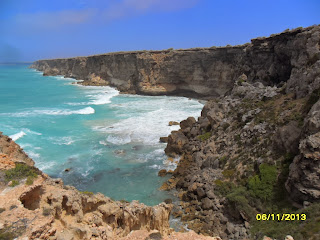
Side
roads lead off to various points to view the coast, and get a cool
breeze from the 38-42 degree heat. At Bunda Cliffs, we were forced
away from the viewing point by armies of flies determined to suck
every last bit of moisture from us. But we got the photos. At Madura
Pass,before the road drops 90m to the Roe Plain, the view over the
flat landscape below is so expansive one can see the curve of the
earth along the distant horizon.
At
Eucla, the road rises slightly again and shortly after we cross the
border into South Australia, and put our clocks ahead 2½ hours (SA
is on daylight saving – WA is not.) Thereon, pegs every 5
kilometres denote the distance from that border crossing. 25kms,
50kms,100kms gives grateful knowledge we are at least making some
progress along the way. We stop overnight at the 81km peg rest area,
again with the ubiquitous army of flies. As night falls, the flies
depart, the temperature drops from 42 to 30 degrees and a soft breeze
murmurs contentment. Only the infrequent drone of road trains
disturbs the night air.
 |
| Head of the Great Australian Bight |
Next
day a side road takes us to Head of the Bight, northernmost point of
the Great Australian Bight. From June to October this is a breeding
area for right whales, often seen close to the shore. Unfortunately
the whales had gone when we visited, possibly driven off by the
flies. But the view made up for that. At this point, the land drops
sharply into the sea. Rhythmical ocean swells lash constantly at
unrelenting cliffs. Deep indigo seas disappear into a blackening
horizon. Rain is on the way. Somewhere out there, the whales and
their young are migrating back to Antarctica. Behind us lies the
vast bulk of Australia.
 |
| Already driven 900kms- Not far to go now |
That
night,in Cohen rest area, thunder disturbs the sky. Three drops of
rain fall. Then the storm is over. At least the temperature drops,
and the flies go away.
 |
| Welcome to Ceduna, eastern end of Nullarbor |
Next
day, our sixth, a shorter trip passing vast grain fields brings us to
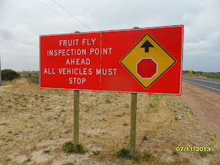
our last golf hole at Penong. We cheat again. Later that day, we
arrive at the quarantine border just shy of Ceduna. We've already
eaten or given away most of our fruit and vegetables, but give up a
small bag of raw potatoes as they may have fruit fly in them. Then
we're in Ceduna, a coastal town with supermarkets and shops and
cheaper fuel and water and paved footpaths. We book into the
caravan park. That night it rains heavily. We're grateful.
 |
| Looking back along the Eyre Highway, Australia's iconic journey |


